
List of unused highways in the United States
An unused highway may reference a highway or highway ramp that was partially or fully constructed but was unused[1][2][3][4][5][6][7][8][9] or later closed.[10][11][12] An unused ramp can be referred to as a stub ramp,[13] stub street,[2][14][15] stub-out,[2] or simply stub.[16][17] The following is a list:
United States
Alabama
- Between Exits 121 and 123 along Interstate 20/Interstate 59 is an abandoned stretch of mainline interstate along the southbound lanes. These lanes were utilized in 1977 as temporary lanes while the mainlines were being repaired as a result of sinkhole formation.[18] [19]
- An unused ramp exists along U.S. Route 11 (1st Avenue North) at its northbound intersection with U.S. Route 31/U.S. Route 280. The ramp was abandoned with the completion of the Interstate 20/Interstate 59 and U.S. 31/U.S. 280 interchange located just to its north.[19] [20]
- Mainline stubs and an exit stub exist at the current western terminus of Interstate 759 at Interstate 59 for an eventual planned extension to U.S. Route 431 west of Attalla. [21] There are also plans to extend I-759 east to U.S. 431/U.S. Route 278.[20] I-759 currently transitions into Alabama State Route 759, a two-lane surface road that connects the interstate to Alabama State Route 291, at its eastern terminus. There is bridgework being done that indicates an upgrade of Alabama 759 to interstate standards.[21] Seen here along with a mainline stub
- A stub exists at the current southern terminus of Alabama State Route 297 after its crossing of the Paul Bryant Bridge at the Jack Warner Parkway. Future plans call for the route to continue southward from this point.[22] [22]
- There is a half-built bypass of Brent and Centreville that carries the U.S. Route 82 and Alabama State Route 219 designation. It currently ends at Alabama State Route 25 as a parclo interchange.[23] [23]
- Construction has started on a bypass of downtown,[23] east of the city center. The bypass is to be in the southeastern quadrant of the area, intersecting Interstate 85 near mile marker 14 and Interstate 65 near mile marker 163.[24] An aerial view shows there is only a short portion of the bypass graded. Part of the route is signed Alabama State Route 293. [24]
- Some full cloverleaf interchanges have been reconfigured and ramps removed. All that remains is the ramp grading. They are located at Interstate 65 and Alabama State Route 16 (Government Blvd) [25], I-65 and Mobile County Road 56 (Airport Blvd) [26], and I-65 and U.S. Route 45 (St Stephens Rd) [27].
- There are mainline stubs on the U.S. Route 80/U.S. Route 280/Alabama State Route 8 (Phenix City Bypass) near where it intersects with the U.S. Route 431/Alabama State Route 1 (280 Bypass) outside the city [28]. The stubs suggest a possible extension.
Arkansas
- At the northern terminus of Interstate 440 at U.S. Route 67/U.S. Route 167, there are stub ramps northward. A lack of funds has prevented I-440 from continuing but there is currently a proposal to install toll booths where U.S. 67/167 and Arkansas State Route 107 intersect the proposed North Belt Loop.[25] [29]
- The grading and underpass for the previous left exit/entrance ramp from U.S. Route 67 southbound to Interstate 40 eastbound are still visible. A new ramp was built to connect to and from the right. [30]
- On the Arkansas side of the Mississippi River, next to the approach to the Memphis & Arkansas Bridge which carries Interstate 55 between West Memphis, Arkansas and Memphis, Tennessee, a ramp stub and roadway extends near the current roadway. [31] Prior to the construction and opening of the new bridge, the Harahan Bridge, one of the railroad bridges that cross the Mississippi at Memphis, also carried automobile and truck traffic on separate platforms from the rail traffic; the ramp stub connected the Arkansas approach road (now I-55) to these platforms. One platform carried traffic eastbound into Memphis. The other platform carried traffic westbound into Arkansas. Each platform only carried one lane of traffic.[26]
California
List of unused highways in California
District of Columbia
- A small ramp stub exists on District of Columbia Route 295, which would have provided a connection to, at one point, Interstate 295, which was the original designation for the unbuilt freeway, or (the unsigned) Interstate 695,[27] whose extension was cancelled in 1996.[28] [32].
- The unsigned Interstate 695 terminates abruptly southwest of Robert F. Kennedy Memorial Stadium, just before the Pennsylvania Avenue overpass.[28] An access road now extends to RFK. [33][34] An aerial shot before (1988) the access road opened.
Connecticut
List of unused highways in Connecticut
Delaware
- At the interchange of the Delaware State Route 141 freeway with Delaware State Route 2 near the city, a stub remains that suggested Delaware Route 141 would have been a high-speed western bypass around the city. As of 2006, the Delaware Department of Transportation was in the process of totally rebuilding a Template:Convert/LoffAoffDbSon section of Delaware Route 141 to transform this low-speed (35 m.p.h.) 4-lane road into a physically divided road with a Template:Convert/mi/h. speed limit (the lower limit due to the location of residences in the area), starting in 2007.[29] [35] AARoads has a photo of the stub [36]
![[36]](http://www.aaroads.com/delaware/delaware100/de-141_nb_exit_006b_02.jpg)
- An on-ramp stub on Delaware State Route 1 north, located at the highway's interchange with Bay Road at Dover Air Force Base [37].
- Labeled S Dupont Highway by some maps, obsolete pavement exists as the old alignment of U.S. Route 13. The newer Delaware State Route 1 has taken the place of what was once U.S. 13.[30] The southbound lanes are still in use but the northbound lanes sit unused. [38]
Florida
List of unused highways in Florida
Georgia
List of unused highways in Georgia
Illinois
List of unused highways in Illinois
Indiana
- Indiana State Route 265, which is an extension of Interstate 265 east of Interstate 65, ends currently at Indiana State Route 62. There are signs proclaiming "No bridge to Kentucky." As part of the Ohio River Bridges Project, this interchange is slated for reconstruction, as I-265 is to run southeast into Kentucky via a bridge.[31][32] [39]
- There are grading and stub ramps at the Interstate 70 and 65 interchange (North Split) downtown where Interstate 69 was supposed to have connected, but was cancelled in the 1970s due to community opposition.[33] [40]
Kansas
- South Lawrence Trafficway, which was intended to route Kansas State Route 10 around the city rather than through it. The western section was completed in 1996. An overpass was constructed over U.S. Route 59 to continue the route eastward, but all traffic must exit before reaching it. [41]
- The Oakland Expressway was originally intended to extend further than the US 24, but the highway was only completed up to the US 24. The canceled extension left an unused cloverleaf ramp that was to run from the eastbound US 24 to the Oakland Expwy extension. [42]
Kentucky
- The Pennyrile Parkway was to extend from Interstate 24 near Oak Grove to Henderson.[34] The southernmost seven miles (11 km) were not constructed, however, and a stub was left in Hopkinsville. There are plans in the six-year plan to construct the remaining mileage by 2010.[35] [43]
- Kentucky State Route 841, which also carries the designation Interstate 265 between Interstate 71 and Interstate 65, had two stubs.
- Northwest of Interstate 71, Interstate 265 becomes solely Kentucky 841 and narrows from four-lanes divided to two undivided as a super-two. The highway ends at a stub diamond interchange with U.S. Route 42. As part of the Ohio River Bridges Project, this interchange is slated for redesign using a modified half-diamond interchange with I-265 continuing northwestward to Indiana via a tunnel and bridge.[31][32] [44]
- Southwest of the city past Interstate 65, where Interstate 265 becomes Kentucky 841, the highway formerly dead-ended at U.S. Route 31W and U.S. Route 60. The interchange was reconstructed as part of an extension of Kentucky State Route 1934, otherwise known as the Greenbelt Highway.[36][37][38] The original grading is still present. [45] Former configuration
- Along Interstate 471 near the Ohio River, a stub on-ramp would have connected Lexington Avenue and East Fourth Street to I-471, providing relief for the Kentucky State Route 8 interchange.[39] [46]
- The Western Kentucky Parkway was a toll road extending from Princeton to Elizabethtown.[34] The original western terminus was with U.S. Route 62 from 1963 to 1968, when the parkway was extended westward to Interstate 24.[40] An old map and the current configuration show the elimination of any and all stub pavement.
- The Cumberland Gap Tunnel replaced the two lane U.S. Route 25E over the Gap to allow four lanes of traffic to travel the route. The existing road was closed except for a short section used by The National Park Service. The pavement was removed in 2002 to restore the former route of the road to its historic appearance.[41] [47]
Louisiana
- The eastern terminus of Interstate 220 contains several stub ramps and the grading for the remainder of the interchange. There is debate about connecting to today's Louisiana State Route 3132 south of the city.[42] [48]
- Somewhat related to this, at the eastern terminus of Louisiana State Route 3132, there is a half-complete diamond interchange. Its current planned endpoint is Louisiana State Route 523/E Flournoy Lucas Road. As mentioned above, there is debate about extending Louisiana 3132 to Interstate 220/Interstate 20 east of the city.[42] [49]
- The northern terminus of Interstate 49 at the Interstate 20 interchange contains numerous stub ramps that indicated a previously designed northern extension. As early as 1999,[43] this idea was scrapped with the adoption of the Future 49/High Priority Corridor 1, a plan to extend I-49 to Kansas City. It was due to high costs in acquiring right of way and community opposition.[44] This plan currently has I-49 routed onto Louisiana State Route 3132 south of the city. Currently, there are talks to turn the current stretch of I-49 from Louisiana 3132 north to its current northern terminus into Interstate 149.[45] [50]
- On Interstate 10, in the easternmost part of Orleans Parish, between exits 248 (Michoud Boulevard) and 251 (Bayou Sauvage National Wildlife Refuge), is abandoned exit 250 [51], complete with overpass, whose ramps were overgrown with vegetation and (at least before Hurricane Katrina) barricaded from use by travelers on the highway.[46] [52]
![[51]](http://www.southeastroads.com/louisiana001/i-010_eb_exit_250_02.jpg)
- Louisiana State Highway 3139 (Earhart Expressway) in Jefferson Parish features several stub ramps, as it was never fully completed. The northern terminus was planned to be Louisiana State Highway 49 (Williams Boulevard) but it currently only reaches Louisiana State Highway 3154. Two mainline stubs exist at the Louisiana 3154 exit, leaving Louisiana 3139 to utilize the ramps instead. [53] Two more stubs were to be part of a direct connection to Causeway Boulevard. That connection was never completed, leaving the stubs [54] and an abandoned grassy right-of-way. [55] Another stub, this one an off-ramp, exists on southbound side near the eastern end of the limited-access portion. [56] It had a companion on-ramp stub on the northbound side,[47] but it has since been completed. An additional off-ramp stub on the southbound side [57] was to have connected to the proposed Interstate 310/Vieux Carre Riverfront Expressway south of the French Quarter had it continued as a freeway south into Orleans Parish.[48]
- Interstate 310 currently ends at U.S. Route 90 west of the city. Originally, Interstate 410/The Dixie Freeway was to be the southern bypass of New Orleans and connect what are now Interstates 310 and 510, but it was cancelled in 1977 due to environmental lawsuits[49] and the miles were transferred to Interstate 49.[50] However, when it was built, mainline stubs were built at the southern terminus in the hope that a continuation would eventually be built. These stubs will be utilized when Interstate 49 is extended to New Orleans, as the current plan has I-49 routed just south of the I-310/U.S. 90 interchange.[51] [58]
Maine
- Interstate 195 has an interchange with the Maine Turnpike/Interstate 95 at its western terminus. As originally constructed, both ramps were clover ramps, but subsequently, the clover ramp handling traffic exiting the turnpike was replaced between 1988 and 1998,[52] turning the interchange into a trumpet. The grade for the original clover ramp remains. Also, the eastbound ramp from the Turnpike crosses a bridge meant for two lanes, but only has one and shifts over to the left, as can be seen from the link. [59]
- Where Interstate 295 meets Maine Turnpike/Interstate 95 at its northern terminus, several ramps were replaced, between 1991 and 1996,[53] with simpler diamond and half trumpet interchanges with Maine State Route 9 and Maine State Route 126. As can be seen from the Google map aerial, the gradings for these ramps are clearly visible. There is also an old overpass bridge that is now a toll plaza on I-295. This is at exits 102 (Lewiston Rd.) and 103 (I-295 south). [60]
Maryland
List of unused highways in Maryland
Massachusetts
List of unused highways in Massachusetts
Michigan
List of unused highways in Michigan
Minnesota
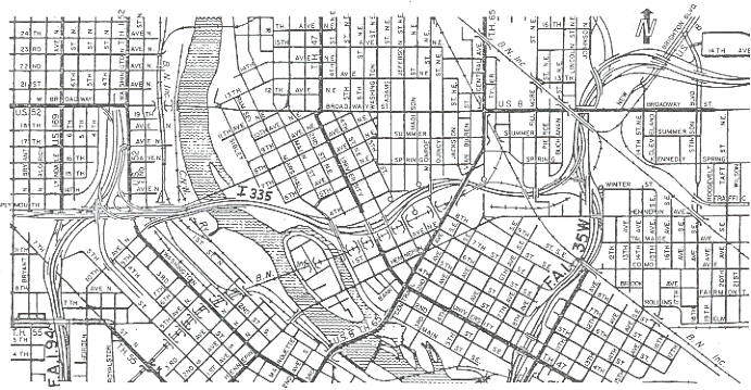
- Interstate 335, a spur of Interstate 35W, was proposed to connect I-35W with Interstate 94 just north of downtown. The project got as far as right-of-way acquisition and grading for and paving of exit ramps at the east end on I-35W before it got cancelled due to local opposition. The southbound lanes of I-35W contain the vestiges of an entrance ramp from I-335 and a ramp to I-335 from the northbound lanes is visible despite having been demolished. Both are near the Hennepin Avenue bridge. [61] North of this, the other half of the proposed full interchange is also visible. The exit from I-35W south to I-335 west is still graded and a stub of pavement that still exists was to be the ramp from I-335 east to I-35W north. [62] A northbound exit from I-35W to Johnson Street makes a rather long dogleg that would have accommodated this ramp and the redundant Johnson Street exits support an I-335 merge. In the same area, a pavement stub existed in the I-35W median but has since been removed.[54] [63]
- At the west end of the proposed Interstate 335[54] there is pavement to support a wider ramp on the exit from eastbound Interstate 94 to N 3rd Street. It was to be the ramp to eastbound I-335.[55] [64]
- In the late 1950s, what is now Minnesota Highway 5 was proposed to follow a more direct, part-freeway/part-arterial routing between downtown St. Paul and the existing 4-lane segment along MN 5 east of Minnesota Highway 120. The northern MN 5/MN 120 junction includes some ramp grading for what was then planned as a folded diamond interchange, but cancelled along with the rest of the proposed highway sometime in the 1970s.[56] What was to be the eastbound off-ramp loop is now used as an access road to a Minnesota Department of Transportation staging area, as can be seen in aerial image.
- Interstate 94 exit 195 for Wright County Road 75 (westbound only) and the corresponding eastbound on-ramp were closed and replaced in 2006 by exit 194 (Wright County Roads 18 and 39),[57] with ramps from the former exit 195 barricaded but still intact. This Google map image shows the former exit 195 visible in the satellite image with the layout of the current exit 194 drawn in orange: [65]
Mississippi
- Stub roadways exist at the intersection of Mississippi State Highway 475 and Old Brandon Road near Jackson-Evers International Airport. [66] The interchange may one day be completed if Mississippi State Highway 475 is realigned in the area.
- Right-of-way for a loop ramp and a collector-distributor roadway exists at the interchange of Interstate 59 and U.S. Route 98 at the southern edge of the city. [67] U.S. 98 may one day be extended west from the interchange to bypass the city.
- The railroad bridge that formerly carried U.S. Highway 80 across the Mississippi River is now closed to automobiles. There is also an abandoned toll house on the Mississippi side. [68]
- Several highways were destroyed when the Tennessee-Tombigbee Waterway was built through east Mississippi. These roads were either bypassed with new spans or deemed too unimportant to bridge across the waterway. Sections of Mississippi State Highway 364 [69], Mississippi State Highway 178 [70], Mississippi State Highway 182 [71], and old alignments of U.S. Highway 45 and Mississippi State Highway 50 [72] are discontinuous at the waterway.
Missouri
- Missouri State Route 21 is a freeway for a portion of its length. The southern freeway portion ends in stubs at Jefferson County Road B. [73] There are plans to extend the freeway portion south of DeSoto.[58]
- An abandoned on-ramp can be seen at Interstate 70 and East Truman Road. The roadbed is still visible, and a bridge over East Truman Road remains unused. [74]
- There used to be an on-ramp to westbound Interstate 70 from Norton Avenue. It was removed after 1995,[59] eliminating a left-hand merge. [75]
- There are stubs and grading of a missing freeway portion of Missouri State Route 13 at U.S. Route 24 to the continuation of Missouri 13 to the south [76].
- A proposed Missouri State Route 755 was to start at Interstate 44 at its interchange with Interstate 55 and connect to Interstate 70, interchanging with Interstate 64/U.S. Route 40. The freeway would have looped to the west of downtown.[60] Indications of the cancelled freeway can be seen in this old satellite image, showing a pavement stub on the Lafayette Avenue exit ramp that has since been removed. There is also blocked off lane on eastbound I-44 that would have been a ramp to northbound Missouri 755.[61] [77] It was to follow Grattan Street, but since the freeway's cancellation, it and Grattan have mostly been replaced by Truman Parkway. Ramp stubs can also be seen around the exits for 20th, Chestnut, and Market Streets from I-64. [78]. A sufficiently large right of way is present there as well.
![[77]](http://www.interstate-guide.com/images044/i-044_et_01.jpg)
- Due to the building of new Busch Stadium, the 8th Street on-ramp to eastbound Interstate 64 was demolished,[62] leaving a ramp stub on the interstate. It is not viewable from the air due to the elevated freeway design downtown, but can be seen while driving. It was a left-entry ramp. The old ramp design can still be seen on a Microsoft Research maps satellite image. [79]
- Spring Avenue once had a viaduct over a rail yard that connected Forest Park Avenue with Gratiot Street. The viaduct was closed and partially demolished sometime after 1991 (and perhaps even after 1998 based on this satellite image). The south end is barricaded by a mound of gravel and the vegetation is overgrown. The north end is blocked by a fence, followed by semi trailers and jersey barriers. Between Interstate 64 and where Scott Avenue would intersect Spring, the viaduct has been demolished and Spring exists as an at-grade street[63] off of Market Street. The remaining elevated roadway has been demolished. [80]
- The MacArthur Bridge formerly carried traffic across the Mississippi River starting 1917, carrying U.S. Route 66 and U.S. Route 460 at times. Due to deterioration, the bridge was closed to automobile traffic in 1981, though trains still use the bridge today. Some of the connections were demolished, including the approach in Illinois [81], though an unused bridge frame [82] and wide supports [83] still stand. Remnants of approaches are used as a parking lot on the west side [84] or are just shut off from traffic by jersey barriers [85]. Pavement still exists on the bridge, though only up to the Illinois side. [86]
- The Interstate 270/Interstate 44 interchange used to be a full cloverleaf with collector/distributor ramps. [87] Two of the loops were replaced with flyovers; the eastbound I-44 ramp to northbound I-270 and the westbound I-44 ramp to southbound I-270. [88] Grading for the demolished loop ramps is still visible from above.
Nebraska
- At the intersection of Interstate 480 and U.S. Route 75 downtown, there are several bridges and ramps that would have connected to the West Expressway, but the West Expressway project was canceled. The interchange is currently under construction and unnecessary bridges and ramps will be removed.[64] [89]
- The bridge over Glenn Cunningham Lake on Nebraska Highway 36 can accommodate a divided highway, but as of 2009, only the southern half of the bridge is used.
- An undivided portion of U.S. Route 385 in western Nebraska has a parallel path for approximately 4 miles ({{rnd/cTemplate:Rnd/b|6.4|(1−0)|1}} km) which is graded, with some bridges constructed, but otherwise unpaved. (Old highway alignment that parallels current alignment.)[90]
New Jersey
List of unused highways in New Jersey
New York
List of unused highways in New York
North Carolina
List of unused highways in North Carolina
Ohio
List of unused highways in Ohio
Oklahoma
- In Tulsa, a section of Interstate 44 was bypassed when the Creek Turnpike was constructed, and I-44 was routed through a new interchange with the northern terminus of the Creek Tpk.[65] The existing pavement is no longer used, and a city street (Pine Street) still crosses the abandoned highway on a bridge. [91] I-44's interchange with Oklahoma State Route 66 also shows signs of the former routing of I-44. There are pavement stubs and grading that indicated a different configuration. [92][93]
Oregon
List of unused highways in Oregon
Pennsylvania
List of unused highways in Pennsylvania
Rhode Island
- The Rhode Island State Route 138 expressway extends westward from its intersection with U.S. Route 1. This was built for the second Interstate 895 that was planned to bypass Providence. This second alignment was submitted for cancellation in December, 1979,[66] which was approved in 1982.[67] [94]
- Just east of the Claiborne Pell-Newport Bridge is a partially unused section of highway with stubs at both ends. The northern stub is part of the never built second alignment of Interstate 895, while the southern stub would have been part of the southbound Rhode Island State Route 238 connector into Newport.[66] [95]
- Interstate 84 was planned, in 1968, to connect Hartford and Providence. It was cancelled in 1982 because of the impending impact on the nearby Scituate Reservoir but there is an indication as to where it was to enter the Providence area. Exits 6A-B for U.S. Route 6 on Interstate 295 was where I-84 was planned to intersect the partial beltway, with stubs on the U.S. 6 mainline and ramp and flyover grading indicating this. There is also a stub on the U.S. 6 to northbound I-295 for the unbuilt flyover. A ramp from I-295 north (exit 6B) that was to go to westbound I-84 has been converted into a turnaround ramp (I-295 north to I-295 south).[68][69] [96]
- There are pavement stubs at either end of the Henderson Bridge and even grading past the eastern end of the highway. The U.S. Route 44 Expressway[70] was intended to cross the bridge but Massachusetts never purchased the land on which to build the expressway.[71] [97] [98]
- There is a stub on-ramp from Rhode Island State Route 1A/Allens Avenue north to Interstate 95 north at exit 19. The ramp from RI 1A interfered with the hurricane barrier's west dike,[72] so it was demolished. The original ramp went over Rhode Island 1A's southbound lanes as seen in this old satellite image. [99].
- There is a stub off ramp from Interstate 195 westbound where Exit 1 used to be. It used to carry traffic into the heart of the financial/court district, as this 2002 picture shows. As of Nov. 2008, there were still signs posted for it. It is currently being used occasionally for staging of construction vehicles working on the new I-195/Interstate 95 connection realignment project. [100]
South Carolina
- Ramp stubs exist where U.S. Route 17 formerly connected to the southern end of Interstate 26. The ramps connected to the John P. Grace Memorial Bridge and the Silas N. Pearman Bridge over the Cooper River. When the bridges were replaced by the Arthur Ravenel Jr. Bridge in 2005, the old roadways were demolished, and a new interchange was built north of the terminus of I-26. [101]
- The South Carolina State Route 277/I. DeQuincey Newman Freeway was originally planned to continue through downtown to Interstate 126 and be numbered Interstate 277.[73][74][75] Following its completion as far as South Carolina State Route 16/Sunset Drive, construction was put on hold due to neighborhood opposition along its proposed routing. The extension was eventually cancelled in the 1980s, and the Bull Street spur was completed in the 1990s, which was supposed to be just an exit. The part of the right-of-way already acquired by South Carolina Department of Transportation was returned to the city in 2001. [102]
South Dakota
- There used to be an Exit 66 on Interstate 90 east of Rapid City for Box Elder and the Ellsworth Air Force Base. This exit was closed October 1, 2003 and the pavement ripped up. A new exit (Exit 67) opened a few months earlier that supplanted Exit 66. This exit is for Liberty Boulevard, which leads right to the gates of the Ellsworth A.F.B. Local officials feared the potential closing of the base and successfully lobbied the state and federal government to construct a new interchange. The exit change will also help keep commercial development away from the runways.[76][77] While the pavement is gone, you can see grading outlining the old ramps. [103] Old configuration
Tennessee
- At the end of the Highway 140 (Pellissippi Parkway) where the parkway meets Highway 33 (Old Knoxville Highway) there are two stubs that end just before the intersection.[104]
- At the southern end of the James White Parkway (Tennessee State Route 71). The parkway is planned[78] to extend to connect to Chapman Highway (U.S. Route 441) somewhere in the vicinity of Gov. John Sevier Highway, but construction has been stalled for several years now, and the parkway now terminates at Sevierville Pike. All traffic enters or leaves the parkway north of Sevierville Pike, but the bridge over the parkway has been completed, and the mainline extends under the bridge, terminating abruptly. [105]
- Just east of the Interstate 40/Interstate 275 interchange along the westbound lanes are a three stub ramps. The first was intended to be an expansion of the mainlanes through downtown and the second two were to be an ramps to and from West Magnolia Avenue. [106]. Both will be eliminated in 2008 as part of the SmartFix reconstruction of I-40 through downtown Knoxville.[79]
- Three pavement stubs exist as a result of a cancelled freeway on the north side of the city. One stub exists just after the Hernando DeSoto Bridge off the elevated ramp from eastbound Interstate 40 to Riverside Drive/Front Street. The ramp may not be visible to drivers, as jersey barriers block it off; however, the unfinished ramp is visible from ground level. [107] On the Jackson Avenue to westbound I-40 on-ramp is another ramp stub. [108] This, along with the above ramp stub, was to connect to a proposed freeway that ran north from this interchange along Mud Island to the Tennessee State Route 300 and U.S. Route 51 (Thomas Street) interchange, where there is also ramp stub.[80] [109] This is also the site where future Interstate 69 will enter Memphis.[81]
- Interstate 40 was planned to go through the city's Overton Park, but public opposition, combined with a court victory by opponents, forced abandonment of the plans. The eastern portion of the road had already been built inside the Interstate 240 loop; the extant highway is currently in use and is now named Sam Cooper Boulevard, while the northern portion of the I-240 loop was redesignated as I-40.[82] [110]
- A stub ramp exists at the Interstate 40/Interstate 240 interchange in East Memphis. [111] It will eventually allow for a two-lane flyover for I-40 westbound to continue through the interchange, relieving the current one-lane ramp of the increased traffic in the region. A corresponding flyover in the eastbound direction will also be built (this will be the fourth level of the interchange) and replace the existing one-lane ramp.[83] In addition, grading remains as the remnant from a loop ramp from westbound I-40 to westbound I-240 which was destroyed after a two-lane flyover replaced it.
- At the intersection of Interstate 55 and U.S. Highway 51 / Elvis Presley Boulevard, a loop ramp has been eliminated. The ramp ran from northbound I-55 to southbound U.S. 51 and was eliminated during the widening of I-55 in 2001 due to weaving conflicts with an on-ramp from Brooks Road immediately before the loop. [112]
- Similarly, a loop ramp from northbound Interstate 55 to westbound Tennessee State Route 175/Shelby Drive was eliminated as part of the widening. [113]
- The western interchange of Interstate 40 and Briley Parkway contains two stub ramps that will eventually carry traffic from eastbound I-40 to northbound Briley Parkway and southbound Briley Parkway to westbound I-40.[84] [114] A pylon [115] in the median of I-40 is further evidence for one of the flyovers.
- The Cumberland Gap Tunnel replaced the two lane U.S. Highway 25E over the Gap to allow four lanes of traffic to travel the route. The existing road was closed except for a short section used by The National Park Service. The pavement was recently removed for more of a historic look.[41] [116]
- Interstate 140 currently ends at Tennessee State Route 33 (Maryville Pike). It is planned to extend further south to U.S. Route 321 (Lamar Alexander Parkway).[85] [117]
Texas
List of unused highways in Texas
Vermont
In Burlington:
- At the west end of Interstate 189 at U.S. Route 7, there are some ramp stubs and about a half mile of an unused highway west of that interchange. There are plans for this to be part of a boulevard into downtown Burlington.[86][118]
- There is a very unusual incomplete fused double trumpet interchange with U.S. Route 7 and Vermont State Route 279. There are ramp stubs for a planned extension of Vermont 279 to Vermont State Route 9, although the interchange will be reconfigured when it is built. [119]
- On both the north and south ends of Vermont State Route 289, there are stubs that indicate an extension of the highway. Original plans had it intersect with Interstate 89 near Williston to the south, and with Interstate 89 near Colchester to the north, to complete an auxiliary highway. [120] 289 also appears to have an unfinished jughandle that is partially paved and graded and leads to what appears to be a soccer field. [121]
- On U.S. Route 4 at the New York state line, there is grading for a trumpet interchange with Vermont State Route 4A. Because U.S. 4 is a two-lane road in New York, the freeway in Vermont ends there, and Vermont 4A has an ordinary intersection with U.S. 4. [122]
- There is a short roadway that once connected Interstate 91 to U.S. Route 5 before the section in Massachusetts was completed. [123]
Virginia
List of unused highways in Virginia
Washington
List of unused highways in Washington
West Virginia
List of unused highways in West Virginia
Wisconsin
- The proposed Stadium Freeway was to have a southern terminus at Interstate 894/Interstate 43 in southern Milwaukee. While the freeway was never built south of National Ave, a graded ramp exists just east of W. Loomis Rd. The ramp was to come from I-894/43 eastbound going north. It was a complete interchange, but one ramp was demolished[87] (it appears it was a flyover as the top level) and there is a hint of a left-exit ramp just west of the proposed interchange. Other ramps exist at this unusually wide interchange and lead to and from a Park & Ride and the left on-ramp from the Park & Ride heading east hints at a planned major interchange. Seen here. [124]
- The Stadium Freeway (signed U.S. Route 41 in this section) was not completed to its planned northern terminus either. It currently ends at Lisbon Road with a wide median and pavement stubs. [125] It was to meet the proposed and planned Park Freeway West in this area and travel northwest for about a mile and head north, intersecting the Bay and Fond du Lac Freeway on its proposed alignment to Interstate 43 (North-South Freeway) in Ozaukee County, where it would end. The extension north of Lisbon Rd. was cancelled in 1974.[87]
- Because a part of the Lake Freeway was canceled after it was planned,[88] extra pavement that was built in anticipation of the northerly continuation, named the "Downtown Loop Closure," sits unused. In one form it is a ramp stub that was to carry the northbound lanes and in another it is a wide bridge that carries less traffic (than originally intended) from Lincoln Memorial Drive to southbound Interstate 794.[87] [126]
- U.S. Route 12 abruptly ends at Wisconsin State Highway 67 just north of the city. Northbound lanes must exit and the mainline continues for about 50 yards. Southbound lanes actually utilize an underpass that was built to carry U.S. 12 northwest toward Whitewater. More unused pavement exists as a never completed on-ramp from southbound U.S. 12 to Wisconsin 67 and an on-ramp (broken up by the operational "flyunder" ramp) from Wisconsin 67 to northbound U.S. 12. Grading is evident on the west side of the interchange. The unbuilt expressway was to be part of a Madison to Chicago route that was limited by Illinois' participation.[89] [127]
- The southern terminus of the interstate quality U.S. Route 12 ends just east of the city. Southbound lanes exit onto a ramp with an interchange with Wisconsin State Highway 120. Northbound lanes merge onto a stub just before a Welcome to Wisconsin rest area. U.S. 12 was to be a part of a fully controlled access freeway from Madison to Chicago, with a connection to the Illinois Tollway System at the state line.[89] There is grading south of the interchange as well. [128]
- Wisconsin State Highway 29 interchanges with Interstate 39/U.S. Route 51 south of the city and had a westbound stub as the highway transitioned into a loop ramp to southbound I-39/U.S. 51. The interchange has since been upgraded.[90] [129]
See also
References
- ↑ "US&R and NY-TF1 Practice for the Real Thing." City of New York 20 June 2005. 15 Jan. 2007 [1].
- ↑ 2.0 2.1 2.2 "Kentucky Model Access Management Ordinance." Kentucky Transportation Cabinet Oct. 2004. 15 Jan. 2007 [2].
- ↑ "Barrie (City) v. 1606533 Ontario Inc.", 2005 CanLII 24746 (ON S.C.). 15 Jan. 2007 [3].
- ↑ Iowa House. 1998. House File 686., 77th, H.R. 0686. [4] [5].
- ↑ "PETITIONED PUBLIC HEALTH ASSESSMENT." New York City. 15 Jan. 2007 [6].
- ↑ House. 1993. LAND TITLE AMENDMENT ACT, 1993. 35th Parliament, 2nd sess., H.R. 78. [7].
- ↑ Munroe, Tapan. "TRENDS ANALYSIS for PARKS & RECREATION: 2000 AND BEYOND." California Park & Recreation Society Jan. 1999. 15 Jan. 2007 [8]
- ↑ "Chapter 5: Detailed Comparison of Alternatives – Seattle." SR 520 Bridge Replacement and HOV Project, Washington Department of Transportation, 2 May. 2005. 15 Jan. 2007 [9] [10].
- ↑ Anderson, Steve. "CT 11 Expressway." New York City Roads. 15 Jan. 2007 [11].
- ↑ "Leasing of Closed Highways Regulation", Alta. Reg. 36/1986. 15 Jan. 2007 [12].
- ↑ "R. v. Sanders", 2004 NBPC 12 (CanLII). 15 Jan. 2007 [13].
- ↑ "HIGHWAY CLOSINGS", R.R.O. 1990, Reg. 599. 15 Jan. 2007 [14].
- ↑ Template:PDFlink, accessed December 28, 2006
- ↑ Sommer, Dick. "Ten Ways to Manage Roadway Access in Your Community." Ohio Department of Transportation, 2005. 15 Jan. 2007 [15].
- ↑ Bauserman, Christian E. "DELAWARE COUNTY ENGINEER’S DESIGN, CONSTRUCTION & SURVEYING STANDARDS." 18 May 1998. 15 Jan. 2007 [16].
- ↑ Geiger, Gene. "Ohio DOT Constructs I-670 over a Water Treatment Sludge Lagoon in Columbus." Ohio LTAP Quarterly. Ohio Department of Transportation. 15:3 (1999) [17].
- ↑ "CITY OF UNION, KENTUCKY." City of Union, Kentucky 23 June 2006. 15 Jan. 2007 [18].
- ↑ MacDonald, Ginny (April 14, 2000). "Warning: Sinkholes Ahead". The Birmingham News: pp. News.
- ↑ "Alabama U.S. Highway 11". AARoads. http://www.southeastroads.com/us-011_al.html.
- ↑ "I-759 Alabama". kurumi.com. http://www.kurumi.com/roads/3di/ix59.html#759al.
- ↑ "Alabama Interstate 759". AARoads.com. http://www.southeastroads.com/i-759_al.html.
- ↑ Beyerle, Dana (December 17, 2006). "Changes in bypass route requested". The Tuscaloosa News. http://www.tuscaloosanews.com/apps/pbcs.dll/article?AID=/20061217/NEWS/612170375&SearchID=73266449835393.
- ↑ 23.0 23.1 "Alabama Fantasy Freeways". ajfroggie.com. http://www.ajfroggie.com/roads/fictional/alabama/index.html.
- ↑ "Interstate 65 northbound - Baldwin County to Prattville". AARoads.com. http://www.southeastroads.com/i-065b_al.html.
- ↑ HOFHEIMER, John. "Tolls could finance last leg of North Belt". Arkansas Leader. http://www.arkansasleader.com/2007/02/top-story-tolls-could-finance-last-leg.html.
- ↑ Cox, Steve. "Harlahan Bridge". Steve Cox Dot Com. http://www.stevecox.com/harahan/part3.htm.
- ↑ "Anacostia Freeway". Eastern Roads. http://www.dcroads.net/roads/anacostia/.
- ↑ 28.0 28.1 Kozel, Scott. "Washington D.C. Interstates and Freeways". Roads to the Future. http://www.roadstothefuture.com/DC_Interstate_Fwy.html.
- ↑ "SR 141, Centre Road, Kirkwood Highway to Faulkland Road". Delaware Department of Transportation. http://www.deldot.gov/information/projects/center_road/index.shtml.
- ↑ "Old US 13". The Alpsroads.net Portal. http://www.alpsroads.net/roads/de/old_13/.
- ↑ 31.0 31.1 Template:Cite press release
- ↑ 32.0 32.1 Template:Cite press release
- ↑ O'Malley, Chris. "Indy rapid-transit plans gain speed, but drivers might not give up keys". Indiana Economic Digest. http://www.indianaeconomicdigest.net/main.asp?Search=1&ArticleID=27996&SectionID=31&SubSectionID=202&S=1.
- ↑ 34.0 34.1 Campbell, Tracy. Interstate Highway System in Kentucky. Kentucky Transportation Cabinet, Department of Highways.
- ↑ Carlyle, Jeffrey. "Edward T. Breathitt Pennyrile Parkway". KentuckyRoads.com. http://www.kentuckyroads.com/pennyrile_parkway/.
- ↑ Finley, Gabrielle (13 August 2003). "Accidents on new Greenbelt link a concern". The Courier-Journal [Louisville].
- ↑ Sheldon, Shafer (13 July 2000). "Greenbelt Highway; Many eager for road's completion". The Courier-Journal [Louisville].
- ↑ Pike, Bill (30 August 2000). "Greenbelt's last stretch opens to praise". The Courier-Journal [Louisville].
- ↑ Mecklenborg, Jake. "INTERSTATE 471". Cincinnati-Transit.net. http://www.cincinnati-transit.net/471.html. Retrieved on 2006-12-28.
- ↑ Carlyle, Jeffrey. "Wendell H. Ford Western Kentucky Parkway". KentuckyRoads.com. http://www.kentuckyroads.com/western_kentucky_parkway/.
- ↑ 41.0 41.1 Droz, Robert. "Old US 25E : Crossing the Cumberland Gap". http://www.us-highways.com/cgap00.htm.
- ↑ 42.0 42.1 "Interstate 220 Louisiana". AARoads. http://www.interstate-guide.com/i-220_la.html.
- ↑ "I-49 extension would result in relocations". The Advocate. http://pqasb.pqarchiver.com/theadvocate/access/44357797.html?dids=44357797:44357797&FMT=ABS&FMTS=ABS:FT&date=Sep+1%2C+1999&author=&pub=Advocate&edition=&startpage=6.B.S&desc=I-49+extension+would+result+in+relocations.
- ↑ "Interstate 49 Northbound (Shreveport Vicinity)". AARoads. http://www.southeastroads.com/i-049c_la.html.
- ↑ "Interstate 49". AARoads. http://www.interstate-guide.com/i-049.html.
- ↑ "Interstate 10 Eastbound (New Orleans to Mississippi)". AARoads. http://www.southeastroads.com/i-010e_la.html.
- ↑ "Louisiana 3139". SouthEastRoads.com. http://www.southeastroads.com/la-3139.html.
- ↑ "New Orleans". SouthEastRoads.com. http://www.southeastroads.com/new_orleans.html.
- ↑ "The Second Battle of New Orleans: Vieux Carré Riverfront Expressway (I-310)". Federal Highway Administration. http://www.fhwa.dot.gov/infrastructure/neworleans.htm.
- ↑ "Interstate 410". kurumi.com. http://www.kurumi.com/roads/3di/i410.html#410la.
- ↑ "U.S. Highway 90 Louisiana - Eastbound". SouthEastRoads.com. http://www.southeastroads.com/us-090ea_la.html.
- ↑ "4 km N of Biddeford, Maine, United States 7/1/1988". TerraServer. http://www.terraserver-usa.com/image.aspx?T=2&S=13&Z=19&X=239&Y=3012&W=1&qs=%7csaco%7cme%7c.
- ↑ "4 km W of Gardiner, Maine, United States 7/1/1991". TerraServer. http://www.terraserver-usa.com/image.aspx?T=2&S=11&Z=19&X=1084&Y=12238&W=1&qs=%7clibby+hill%7cme%7c.
- ↑ 54.0 54.1 "I-335 Minneapolis North Loop". ajfroggie.com. http://www.ajfroggie.com/roads/minnesota/cancelled/i335.htm.
- ↑ "I-335 Minneapolis North Loop". ajfroggie.com. http://www.ajfroggie.com/roads/minnesota/cancelled/maps/i335.gif.
- ↑ Scott, Steve. "Many Pitches for State Land". Saint Paul Pioneer Press. http://www.accessmylibrary.com/coms2/summary_0286-9510464_ITM.
- ↑ "New Interstate 94/Wright County Highway 18 interchange to open in Monticello". Minnesota Department of Transportation. http://www.dot.state.mn.us/d3/newsrels/06/08/25_i94augusta.html.
- ↑ "Route 21 Corridor Projects". MODOT. http://www.modot.mo.gov/stlouis/major_projects/documents/MapofRoute21CorridorProjects.pdf.
- ↑ url=http://msrmaps.com/image.aspx?T=2&S=11&Z=15&X=917&Y=10814&W=1&qs=%7ckansas+city%7cmo%7c
- ↑ "Interstate 44". AARoads. http://www.interstate-guide.com/i-044.html.
- ↑ "Interstate 44". interstate-guide.com. http://www.interstate-guide.com/i-044.html.
- ↑ "MoDOT to Hold Public Hearing on Design of New 8th Street Ramp". St. Louis Front Page. http://www.slfp.com/ComNews010404.htm.
- ↑ Zavist, Jim. "Spring in Summertime". Urban Review STL. http://www.urbanreviewstl.com/?p=3193#comments.
- ↑ "US 75/I-480 Interchange Project". Nebraska Department of Roads. http://www.nebraskatransportation.org/projects/480-75/index.htm.
- ↑ McMahon, Martin. "Oklahoma Terminus: Creek Turnpike". Roadklahoma. http://www.tulok.net/roads/u-crk.html.
- ↑ 66.0 66.1 Anderson, Steve. "Interstate 895-Rhode Island (unbuilt)". bostonroads.com. http://www.bostonroads.com/roads/I-895_RI/.
- ↑ "I-895 (cancelled) Rhode Island; Massachusetts". Kurumi. http://www.kurumi.com/roads/3di/i895.html#895ri.
- ↑ Anderson, Steve. "Dennis J Roberts Expressway (US 6)". Bostonroads.com. http://www.bostonroads.com/roads/US-6_RI/.
- ↑ Anderson, Steve. "Interstate 295-Rhode Island". Bostonroads.com. http://www.bostonroads.com/roads/I-295_RI/.
- ↑ Anderson, Steve. "Unbuild Roads in Rhode Island". Bostonroads.com. http://www.bostonroads.com/roads/unbuilt_RI/.
- ↑ Anderson, Steve. "US 44 Expressway-Massachusetts". Bostonroads.com. http://www.bostonroads.com/roads/US-44_MA/.
- ↑ "Fox Point Hurricane Barrier". Providenceri.com. http://www.providenceri.com/publicworks/hurricane/description1.html.
- ↑ "Interstate 126". Southeastroads.com. http://www.southeastroads.com/i-126_sc.html.
- ↑ "Interstate 20". Southeastroads.com. http://www.southeastroads.com/i-020_sc.html.
- ↑ "Interstate Business Route 26". Interstate-Guide.com. http://www.interstate-guide.com/business-routes/bus26.html.
- ↑ "Exit 66 now road to nowhere." Rapid City Journal. October 2, 2003
- ↑ "Interstate 90". AARoads.com. http://www.interstate-guide.com/i-090.html.
- ↑ Template:Cite press release
- ↑ "I-40/James White Parkway/Hall of Fame Drive: A SmartFix Project". Tennessee Department of Transportation. http://www.tdot.state.tn.us/smartfix/jwp/location2.asp.
- ↑ Lawrence, Chris. "Tennessee Highway 300". LordSutch.com. http://www.lordsutch.com/roads/tn300/.
- ↑ Lawrence, Chris. "I-69 Metropolitan Memphis Routing". I69Info.com. http://www.i69info.com/memphis.html.
- ↑ Gulyas, Sandor. "Memphis Highways". roadfan.com. http://www.roadfan.com/memtran.html.
- ↑ "I-40/I-240 Interchange Reconstruction". Tennessee Department of Transportation. http://www.tdot.state.tn.us/i40memphis/projdraw.htm.
- ↑ "Upgrading Briley Parkway". Infolink. http://www.infolink.com.au/n/Upgrading-Briley-Parkway-n759451.
- ↑ "Interstate 140". SouthEastRoads.com. http://southeastroads.com/i-140_tn.html.
- ↑ Welch, Victoria (December 1, 2006). "Residents frustrated over Champlain Parkway". The Burlington Free Press. http://www.burlingtonfreepress.com/apps/pbcs.dll/article?AID=/20061201/NEWS02/612010308/1007.
- ↑ 87.0 87.1 87.2 Bessert, Christopher. "Milwaukee Freeways". Wisconsin Highways. http://www.wisconsinhighways.org/milwaukee/index.html.
- ↑ Bessert, Christopher. "Milwaukee Freeways". Wisconsin Highways. http://www.wisconsinhighways.org/milwaukee/system_map.html.
- ↑ 89.0 89.1 Bessert, Christopher. "Highways 10 through 19". Wisconsin Highways. http://www.wisconsinhighways.org/listings/WiscHwys10-19.html#US-012.
- ↑ Wisconsin Department of Transportation. "US-51/WI-29 Project". http://www.5129wausau.com. Retrieved on 2008-12-01.
External links
- Unsung Monuments in "The Monument City" - photographic essay of Baltimore area stubs